Building Flood Resilience in the Mekong River Basin
Every monsoon season, communes along the Mekong River face high flood risks that threaten lives, livelihoods, and resources. To strengthen preparedness, the Preparedness Partnership of Cambodia (PPC) is supporting the establishment of locally led Early Warning Systems (EWS) in four flood-prone communes: Svay Klaing, Prek A-Chi, Chiro 1, and Tonle Bet.
Installing Localized Flood Monitoring Systems
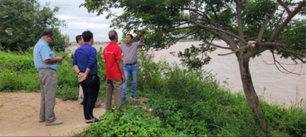
Timely and location-specific early warning messages are critical for minimizing flood losses. Ahead of the monsoon, PPC organized workshops from 08-11 July 2025 in each commune to raise awareness on flood impacts and build a shared understanding of community-based flood risk management.
The workshops demonstrated how a flood level indicator installed at a publicly accessible site can help track rising river levels. Information is then disseminated by trained community members and “BroChea Kapea” (village security volunteers), enabling people to decide when to harvest, evacuate, or relocate assets.
Following the workshops, PPC teams and participants conducted site visits to select suitable locations for installing flood markers and signage. Markers were placed along the riverside, while information signage boards were installed in highly visible public spaces such as police offices, bridges, and village gathering points.
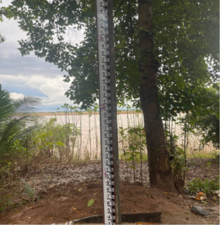
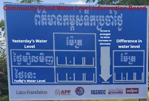
Each flood marker displays the water level in centimeters, while the signage board is updated daily to show both the previous and current water levels. This comparison allows communities to monitor river level changes in real time.
Developing Locally Defined Thresholds and Triggers
Local knowledge plays a vital role in making early warning systems effective. Communities, based on their historical experiences, know which low-lying areas and households are most vulnerable.
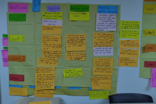
During the upcoming monsoon season, water level changes and their impacts will be recorded to establish a baseline. PPC will convene commune-level meetings to triangulate local knowledge with collected data. This process will help identify specific thresholds—measured in centimeters—linked to impacts such as crop damage, household flooding, or the need for evacuation.
Once thresholds are finalized, communities will be trained on trigger actions:
- Early harvesting of crops
- Evacuation of families from vulnerable houses
- Relocation of assets to safer areas
When water levels surpass these thresholds, the signage will serve as a real-time trigger for communities to implement locally led actions.
Conclusion
The installation of flood markers and information signage marks an important step toward building community-owned early warning systems in Cambodia. By combining scientific monitoring with local knowledge, the communes of Svay Klaing, Prek A-Chi, Chiro 1, and Tonle Bet will enter the 2026 monsoon season better prepared to respond effectively, reducing losses and strengthening resilience in the face of climate change.

