Tarlac City, Philippines | 5 August 2025
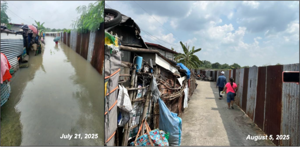
Following severe flooding caused by enhanced habagat (southwest monsoon) in July 2025, a flood hazard assessment was conducted in Barangays San Isidro and Tibag of Tarlac City to better understand flood drivers, impacts, and priority risk areas.
The assessment was carried out by the Philippine Preparedness Partnership (PhilPrep), a multi-stakeholder platform composed of the Office of Civil Defense (OCD) representing the government, the UP Resilience Institute (UPRI) representing the academe, the Philippine Disaster Resilience Foundation (PDRF) representing the private sector, and the Center for Disaster Preparedness (CDP) representing civil society. PhilPrep is a member of the Asian Preparedness Partnership (APP), ADPC’s regional multi-stakeholder localization program supported by the Gates Foundation.
The activity forms part of PhilPrep’s locally led initiative, Talaghay (meaning “resilience”), which is funded by the APP’s Asian Disaster Readiness Fund (ADRF) and aims to integrate technology, research, and local knowledge to protect communities most vulnerable to flooding. The flood hazard assessment was led by UPRI, combining scientific analysis with community-based processes.
Understanding Flood Risks Beyond Administrative Boundaries
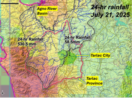
The assessment examined hydro-meteorological processes and flood impacts following intense rainfall from 20–22 July 2025. Satellite-derived data showed that 530.5 mm of rainfall fell within 24 hours in the mountainous areas of Tarlac Province on 21 July—equivalent to more than a month’s average July rainfall—while Tarlac City itself recorded only 58.5 mm. Despite lower local rainfall, severe flooding occurred due to upstream watershed dynamics, underscoring the need to monitor rainfall across the entire river basin, not only within barangay boundaries.
Mapping Flood Hazards and Impacts at Barangay Level
Using field observations, community interviews, GPS-based documentation, and flood hazard maps from UPRI–NOAH, the team identified two primary flood sources: creek systems and the Tarlac River. In Barangay Tibag, particularly Sitio Bacuit, floodwaters exceeded the height of an average person, with affected houses located in high-risk zones identified in the 25-year return period flood hazard maps. Agricultural areas in Sitio Barbon were also inundated, confirming exposure of farming livelihoods to recurring floods.
In Barangay San Isidro, houses built beyond protective dikes along the Tarlac River were destroyed by high-velocity river flows, forcing families to evacuate. These structures were found to be located within flood hazard zones shown in the 100-year return period maps, reinforcing the risks associated with settlement in high-exposure areas.
From Risk Assessment to Enhanced Early Warning
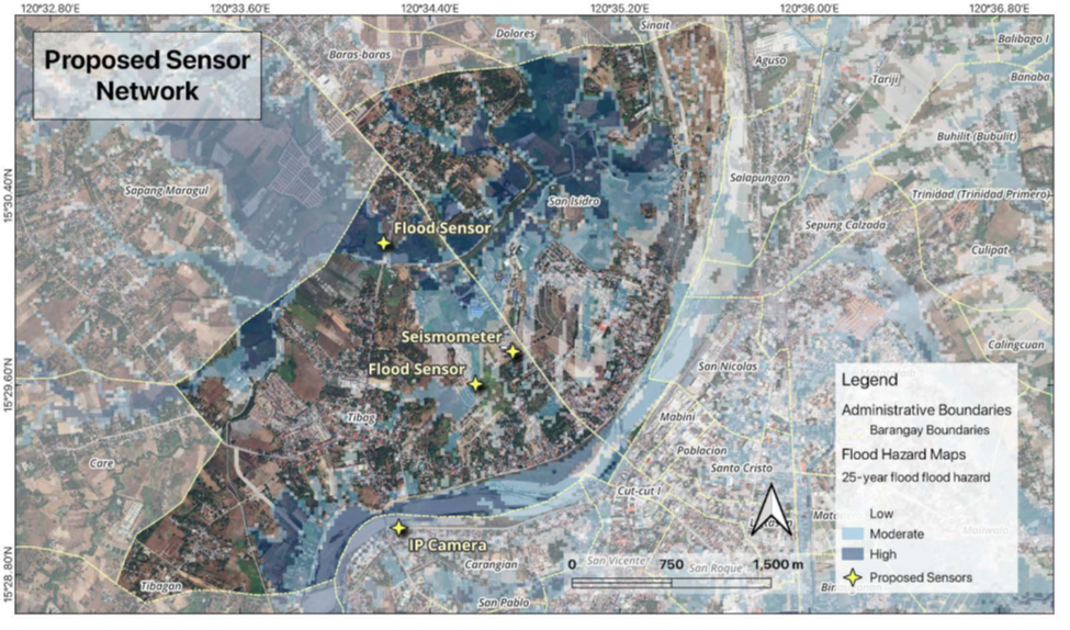
Based on the findings, the assessment proposed the installation of an Internet of Things (IoT)–enabled sensor network to strengthen early warning capabilities in both barangays. The proposed system includes flood sensors for creek monitoring, a CCTV camera for real-time river level observation, and a seismometer for earthquake detection. The system is being co-developed by PhilPrep partners, barangay officials, and local governments to support near real-time monitoring and more timely, data-driven warnings for flood-prone communities.
Call to Action
To learn more about how ADPC and the Asian Preparedness Partnership are supporting locally led, technology-enabled disaster preparedness in the Philippines, visit www.adpc.net and www.app.adpc.net.


)